
Minimum temperatures are for the night/early morning, maximum temperatures are for the daytime,
whilst precipitation amounts and probabilities are for the 24 hours from midnight.
Temperatures for the Melbourne observation site (at Olympic Park) are in brackets.
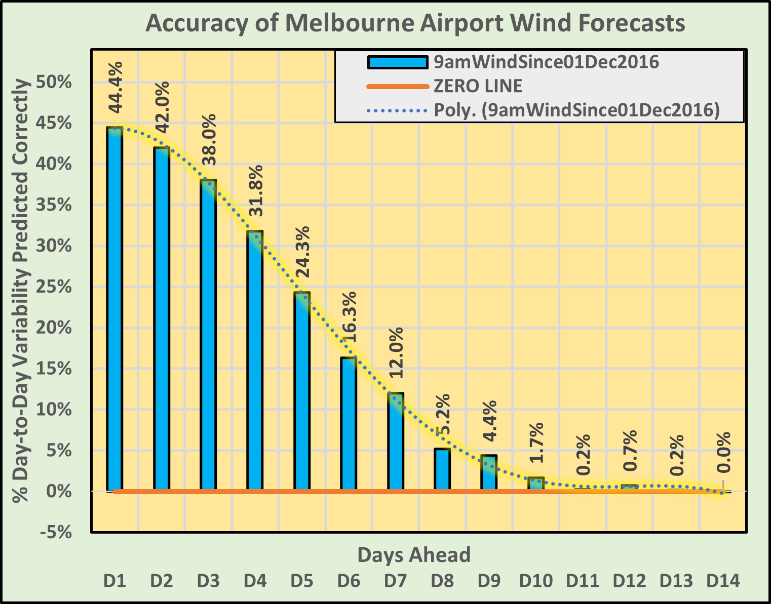
| Day & Date | Morning | Afternoon | Min Temp (deg C) | Max Temp (deg C) | Precip Amount (mm) | Precip Prob (%) | 9am Wind/ 3pm Wind Melb Apt (km/hr) |
|---|---|---|---|---|---|---|---|
| Fri-5-2-2021 | Rain. | Thunder. | 19 (18.1) | 29.2 (29) | 26 | 81 | NNE 10 ESE 20 Gusts55 |
| Sat-6-2-2021 | Cloudy. | Thunder. | 17.2 (16.9) | 26.5 (25.9) | 2 | 57 | N 30 WNW 25 Gusts65 |
| Sun-7-2-2021 | Rain. | Rain. | 15.6 (15.4) | 22.6 (21.2) | 1.6 | 78 | WSW 25 SSW 30 Gusts60 |
| Mon-8-2-2021 | Partly Cloudy. | Sunny. | 13.6 (13.1) | 22.3 (20.7) | 0 | 5 | SSE 12 S 20 Gusts40 |
| Tue-9-2-2021 | Haze. | Haze. | 13.1 (12.3) | 26.4 (25.3) | 0 | 2 | S 8 S 15 Gusts35 |
| Wed-10-2-2021 | Sunny. | Sunny. | 14 (13.2) | 32 (31.2) | 0 | 1 | N 20 N 20 Gusts50 |
| Thu-11-2-2021 | Sunny. | Sunny. | 16.5 (15.8) | 33.1 (32.5) | 0 | 4 | N 20 N 20 Gusts50 |
| Fri-12-2-2021 | Shower. | Thunder. | 20.9 (20.2) | 33.6 (33.2) | 6.6 | 79 | N 35 NNW 30 Gusts70 |
| Sat-13-2-2021 | Rain. | Rain. | 16.8 (16.4) | 23.5 (22.4) | 2.4 | 74 | SW 20 SSW 20 Gusts45 |
| Sun-14-2-2021 | Fog. | Haze. | 14.3 (13.7) | 26 (24.9) | 0 | 3 | S 5 S 15 Gusts35 |
| Mon-15-2-2021 | Sunny. | Partly Cloudy. | 14.4 (13.7) | 33.3 (32.6) | 0 | 6 | N 20 N 20 Gusts50 |
| Tue-16-2-2021 | Cloudy. | Thunder. | 19.6 (18.9) | 32.9 (31.8) | 5.1 | 53 | N 15 NNW 20 Gusts50 |
| Wed-17-2-2021 | Cloudy. | Thunder. | 21.7 (20.9) | 35.8 (35) | 2.3 | 59 | N 35 N 25 Gusts60 |
| Thu-18-2-2021 | Drizzle. | Partly Cloudy. | 20.6 (19.8) | 25.8 (24.6) | 2.2 | 53 | S 8 S 15 Gusts35 |
Acknowledgement: Bureau of Meteorology & World Meteorological Organisation
| Sunny | Dry | Haze | Mist | Fog | Partly Cloudy | Cloudy | Windy | Dust |
| Possible Shower | Drizzle | Shower | Snow | Rain | Thunder | Cyclone |

THREE MONTH OUTLOOK FOR MAR/APR/MAY: NCEP's Depiction of the Global Sea Surface Temperature Evolution The average Indian Ocean Dipole Mode Index for the past week is -0.36 (-0.69 standard deviations), the average Southern Oscillation Index (SOI) for the past 90 days is 12.93, the average SOI for the past 30 days is 18.56, and the latest recorded bimonthly Multivariate ENSO Index (MEI) is -1.16. The expected MEI, adjusted by the Indian Ocean Dipole Mode Index and also by recent values of the SOI, for JAN/FEB is -1. Such a value of MEI indicates a sea surface temperature distribution that corresponds to a weak La Niña. This suggests: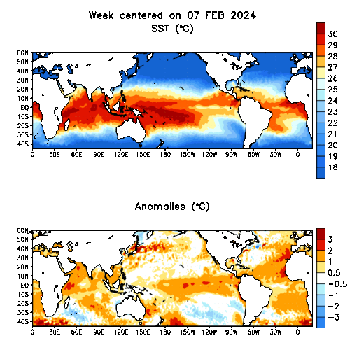
RAINFALL: There is a slightly enhanced chance that total MAR/APR/MAY rainfall will be above normal in the NORTHERN COUNTRY District, there is a very slightly enhanced chance that rainfall will be below normal in the EAST GIPPSLAND District, but there is little indication as to whether rainfall will be below, near or above normal in other Victorian Districts.
OVERNIGHT TEMPERATURES: There is a slightly enhanced chance that average MAR/APR/MAY overnight temperatures will be above normal in the NORTHERN COUNTRY District, there is a very slightly enhanced chance that overnight temperatures will be above normal in the WIMMERA District, but there is little indication as to whether overnight temperatures will be below, near or above normal in other Victorian Districts.
DAYTIME TEMPERATURES: There is a slightly enhanced chance that average MAR/APR/MAY daytime temperatures will be above normal in the WIMMERA and NORTH CENTRAL Districts, there is a very slightly enhanced chance that average MAR/APR/MAY overnight temperatures will be above normal in the WESTERN District, but there is little indication as to whether daytime temperatures will be below, near or above normal in other Victorian Districts.