
| Home | Publications | Presentations | Climate of Victoria | 10 Day Forecasts | Seasonal Outlook | Other Links |
On Tuesday 1st January, 1901, Melbournians awoke to a new century, a new nation and a "fine and pleasant morning". The overnight minimum temperature had been 53.1 deg F (11.7 deg C). By 9am, the temperature had risen to a balmy 71.6 deg F (22.0 deg C) under the influence of a warm northwesterly wind. The sky was a steely blue, there being only a small patch of stratocumulus cloud. The temperature continued to rise, reaching a top of 81.2 deg F (27.3 deg C), just prior to the arrival of a "rather boisterous change", accompanied by thunder. By 9pm, the temperature had dropped back to 62.8 deg F (17.1 deg C) and a "light misty rain" was falling, but the total during the night amounted to a mere 5 points (1.2 mm).
"To observe and understand Australian weather and climate
and provide meteorological, hydrological
and oceanographic services in support of Australia's national
needs and international obligations."
This publication was produced in recognition of the year 2001 being the 100th anniversary of Federation.
Weather affects everybody. Consequently it is of interest not only to residents of an area, but also to visitors. This publication is designed only as a general survey - one to give residents more knowledge of their environment and tourists an idea of what can be expected. The data for Melbourne have been derived mainly from observations taken at the Regional Office instrument site (34 metres above sea level) in Victoria Street on the Carlton edge of the main city block.
In addition to the month-by-month survey of the city area (Table 1), climate statistics for some selected stations in the vicinity are also given to demonstrate variations across the metropolitan area (Table 2). The data for the city site, notable for its relatively mild nights, is representative of the Central Business District. The data for Kew may be taken as fairly representative of the inner suburbs. The data for Aspendale, notable for its relatively cool summer days, reflects the milder climate of the southeastern Bayside suburbs. The data for Scoresby may be taken as fairly representative of the more inland southeastern suburbs. The data for Mt Dandenong and Sherbrooke, notable for their cooler conditions, are typical of the Dandenong Ranges. The data for Tullamarine may be taken as fairly representative of the northwestern suburbs. The data for Bacchus Marsh, and the data for Watsonia and Camberwell, in areas notable for their more continental climates, may be taken as representative of the outer western suburbs and outer eastern suburbs, respectively. Finally, the data for Laverton is representative of the drier southwestern suburbs.
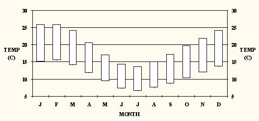
Melbourne's climate is temperate and variable, and moderate rainfall is received in most months (Figs 1 and 2). It is warm in summer, with daytime temperatures averaging in the mid to high 20s, mild in autumn and spring, with daytime temperatures averaging near 20şC, and rather cold in winter, with daytime temperatures averaging in the low to mid teens. Situated about 60 kilometres from the open ocean, the city has a climate midway between maritime and continental, although the extensive landlocked Port Phillip Bay has a moderating effect on temperatures in bayside areas. To illustrate, the bayside suburb of Black Rock has an average summer maximum temperature of 24.3şC. By contrast, the outer northeastern suburb of Watsonia has an average summer maximum of 26.1şC.
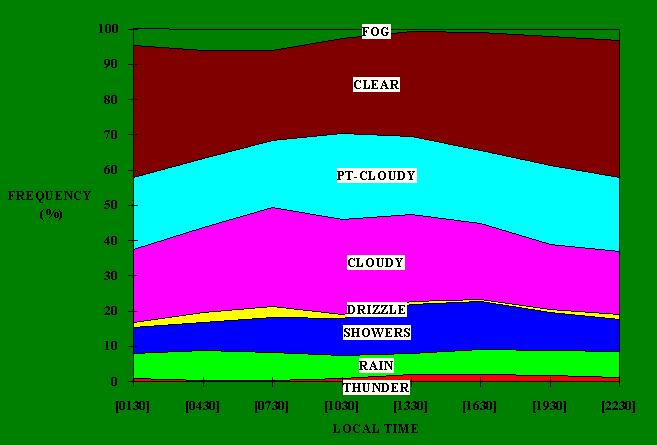
The frequency of fog (Fig 3) peaks during the morning and in early winter. The frequency of clear weather peaks overnight and during the late summer; by contrast, the frequency of cloudy weather (but without precipitation) peaks during the morning and has a "flat" peak extending from late autumn through winter and spring. The frequency of precipitation peaks during the late afternoon and in late winter. With regard to precipitation type, the frequency of drizzle peaks during the morning and in early winter; the frequency of showers (interupted precipitation) peaks during the afternoon and in late winter; the frequency of rain (continuous precipitation) peaks during the morning and in late autumn (with a secondary peak in late winter); and, the frequency of thunderstorms peaks during the afternoon and in summer.
Temperatures in the city have ranged from a low of -2.8şC on 21 July 1869 to a high of 45.6şC on 13 January 1939. Victoria's most disastrous bushfires ever occurred in January 1939, when Melbourne firstly broke a long standing maximum temperature record on the 10th, when 44.7şC was reached, only to break that record three days later. The highest minimum temperature ever recorded was 30.6şC during the night of 31 January - 1 February 1902. The temperature normally exceeds 35şC on 9 days a year. In the summer of 1897-1898 the temperature exceeded 35şC on 25 days.
At the lower end of the scale temperatures now fall below zero only once every three years in the city. This was not always so. In the early years of settlement, sub-zero temperatures were recorded several times a year. The longest period of consecutive nights with such low temperatures is three. This has occurred on a number of occasions, most of which are during the first fifty years of record. However, even now, the city's "heat island" effect, which is the consequence of asphalt and concrete absorbing daytime warmth and radiating it back into the environment during the night, is largely confined to the Central Business District (CBD). In the CBD minimum temperatures are now mostly between 1şC and 2şC above those of most metropolitan locations. During the spells of cold winter mornings, sub-zero temperatures are still recorded in many suburban areas. For example, Moorabbin's temperature falls below zero on two mornings every winter. In the outer northeastern suburbs of Bundoora and Watsonia, and in the outer western suburbs of Werribee and Laverton, sub-zero temperatures are achieved on about six winter mornings every year. The heating effect of the city asphalt and concrete is also observed during the day, albeit to a much lesser extent, with maximum temperatures a few tenths of a degree Celsius above those of nearby metropolitan locations.
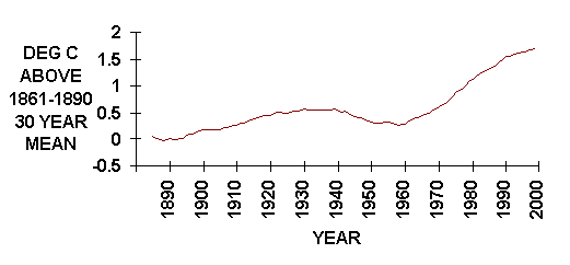
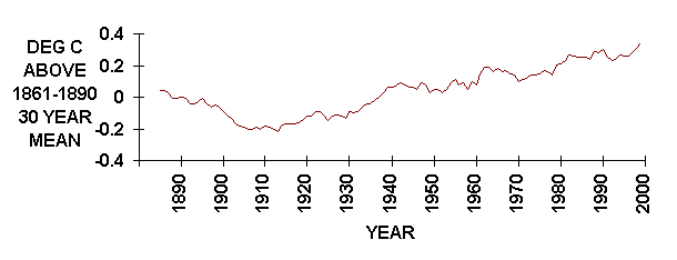
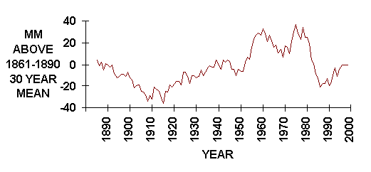
It is interesting to note that the mean minimum temperature derived on the city's first 30 years of recorded data was 9.5şC (1.5şC below that of the 1961-1990 period). The mean maximum temperature derived on the same data was 19.7şC (only 0.3şC below that of the 1961-1990 period). Although the warming indicated by these data (Figs 4 and 5) is largely a consequence of the increasing "heat island" effect, a component of the temperature increase reflects the overall trend to global warming evident during the last 100 years.
A feature of the temperature pattern is the marked changes. Hot spells occur several times each summer when there is a continual rise in temperature during successive days. They are often a consequence of a large anticyclone remaining quasi-stationary over the Tasman Sea. In such circumstances, dry air from the hot interior of the continent is brought over southeastern Australia. For example, Melbourne's most notable heatwave on record occurred in January 1908, when the temperature exceeded 35şC on six consecutive days, including five consecutive days when it reached 40şC. This heatwave is also responsible for producing the city's longest run of consecutive nights when the temperature did not fall below 20şC (six). In December 1960, the temperature exceeded 30şC on every one of the seven days from Christmas to New Year's Eve. In March 1899, there was a ten day spell during which the temperature reached 30şC on all but one of the days.
Hot gusty northerly winds often strengthen with the approach of a southerly change. These cool changes vary in intensity and while some are dry, others may produce rain and thunderstorms. They are often vigorous and between November and March day-to-day falls exceeding 10şC occur occasionally. Temperature falls of this magnitude sometimes take place within a few minutes following the passage of summertime cool changes. Christmas Day 1924's maximum temperature of 31.9şC was followed by a maximum on Boxing Day of only 11.6şC.
In winter, due to the cold continent, anticyclones are centred over inland Australia, and a series of depressions over southern waters provide a persistent zonal flow across southern parts of the continent. However, on occasions when an anticyclone develops a ridge to southern waters and a depression intensifies east of Tasmania, a "cold outbreak" occurs. This brings cold and relatively dry air from southern waters rapidly across Victoria, giving windy, showery weather with some hail and, on rare occasions, snow. Melbourne's heaviest snowfall on record occurred on August 31, 1849, when snow on Melbourne streets was reported to be 30 cm deep in places.
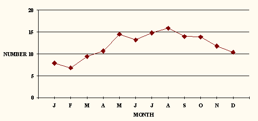
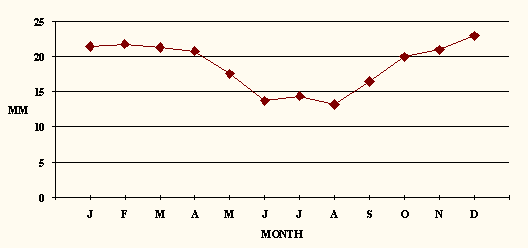
Rainfall is fairly evenly distributed throughout the year, averaging about 55 mm per month for a mean annual total of 639 mm on 143 days, although there have been long term fluctuations in the mean annual total over the period of record (Fig 6). Spring is slightly wetter than other seasons. A considerable portion of the rain comes with westerly winds and cold fronts. Although the total amount of rain received is about the same for winter and summer, it falls on twice as many days in winter than it does in summer (Fig 7). During summer the troposphere is warmer, and therefore can hold more moisture. For this reason, rainfall during the summer months tends to be heavier (Fig 8). However, lifting agents in the form of cold fronts are weaker and are not as frequent as the succession of fronts that pass in winter, so rain days are less frequent in summer.
The eastern suburbs are significantly wetter than the western suburbs. For example, Scoresby has a mean annual total of 901 mm, in contrast to Laverton's 569 mm. The relatively low rainfall to the west of the city is due to a combination of the "rain shadow" effects of the Otway Ranges and the ranges in the Ballarat region. The relatively high rainfall to the east of the city is because moisture in the predominant westerly wind stream condenses as the stream approaches the foothills of the Dandenong Ranges.
Some of Australia's most severe droughts have occurred in association with the El Niño, a warm ocean current that appears for extended periods in the eastern Pacific. When it occurs, the southeast trade winds across the Pacific weaken. As a result, there is less transport of moisture towards tropical Australia. A good example of the potential impact of the El Niño on Victoria occurred during the early 1980s, when Melbourne's third driest year on record (1982) was followed, in February 1983, by the State's second worst bushfire ever in terms of loss of life. However, Melbourne's driest year of 1967, when the 332.3 mm received was spread over 107 days, was not associated with an El Niño. By contrast, Melbourne's wettest year on record of 1916, when 967.5 mm fell on 167 days, was associated with El Niño's "opposite", the La Niña. The longest dry spell ever recorded in Melbourne was forty days, during the summer of 1954-1955.
One of the greatest rain producing systems is a weak surface depression whose centre moves inland across the State and which extends upwards in the atmosphere to 5000 metres or more. When warm moist air advected from the Tasman Sea at low levels of the atmosphere combines with moist air from the Indian Ocean that has been advected across the continent in the higher levels of the atmosphere, the presence of such a system can give very heavy rainfall. Not infrequently the "upper low" may be present without any indication at the surface. Melbourne's wettest day on record occurred in January 1963, when 129.8 mm fell between midnight and midnight on the 28th, in association with just such a development. On other occasions, these inland depressions are not closed systems, but are "troughs in the easterlies", and when moisture is present these can also produce general rain. These are more common in the summer months, when moist, humid air from the Tasman Sea is brought over southern Victoria. Alternatively, when intense low pressure systems develop over the interior and move southeast across Victoria, they often bring several days of persistent rain.
Thunderstorms are more frequent during late spring and summer, when there is adequate surface heating to provide energy for convection, than at other times of the year. In February 1972, 78 mm fell in one hour during a thunderstorm. Hail is observed more often during winter and spring. Duststorms and tornados are rare. However, on February 8, 1983, a duststorm reduced visibility in the city to 100 metres. In February 1918 a violent tornado sweeping across Port Phillip Bay crossed the shoreline at Brighton, caused two deaths, and devastated houses from Brighton to Bentleigh.
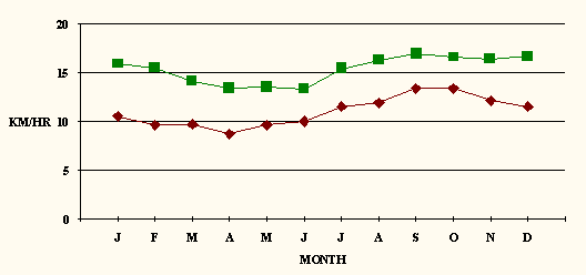
The wind varies from day to night and from season to season. Wind speed is usually lowest during the night and early hours of the morning prior to sunrise. It increases during the course of the day as heating of the earth's surface induces turbulence in the wind stream (Fig 9). Wind also varies with very localised effects of some weather phenomena such as showers and thunderstorms. Examples of the diurnal variation are the sea breeze, which brings relief on many hot days, and the valley or katabatic breeze, which brings cold air from inland Victoria down valleys during the night and early morning towards Melbourne. These breezes are responsible for winds being more often from the north during winter, particularly during the morning. They are also responsible for winds being more often from the south during summer, particularly during the afternoon. This is in spite of the predominant wind stream being westerly in origin. There is a marked tendency for the very windy days to occur during the late winter and early spring months. Melbourne's strongest wind gust on record is 120 km/hr on September 3, 1982.
Fog is primarily a late autumn and winter phenomenon. When an anticyclone moves slowly across Victoria, a prolonged spell of fine weather results with frost and fog. Fog usually is confined to the overnight period, but occasionally persists beyond mid-morning. Melbourne's foggiest month was June 1937, when there was some fog on 20 of the days. As a result of persistent fog on the weekend of July 7-8, 1973, maximum temperatures on the two days were respectively 7.2şC and 7.4şC. Melbourne's coldest day on record, July 4, 1901 (maximum 4.4şC) was also a day of persistent fog.
It is high summer in Melbourne in January and February and typical days are warm and sunny with a freshening sea-breeze from the south in the afternoon. A few days are cool and cloudy, a maximum temperature below 20şC being recorded about once a week. There are always hot days and the year's highest temperature of about 40şC is usually recorded during these months. Some of the hot days are accompanied by an unpleasant north wind, which can be quite strong. Mostly there are only one or two hot days in a row. Occasionally hot weather continues for three or more days, sometimes relieved by a sea-breeze in the afternoon, at other times with hot and oppressive nights. The year's warmest night, with a minimum temperature of about 24şC, is usually recorded during these months. Hot weather usually ends with an abrupt cool change when the temperature may fall by 10şC in 20 minutes. Some of these changes are dry; others are accompanied by showers and thunderstorms. Humidity conditions are uncomfortable on some days, mostly towards the end of a hot spell. It is not uncommon for a fortnight to pass without rain. On occasions prolonged heavy rain can fall.
March is a transitional month between summer and autumn. Hot weather can be experienced in the first fortnight, when the month's highest temperature of about 35şC is usually recorded, and it may be accompanied by a strong northerly wind during the day. The hot weather usually comes to an end with a sharp wind change to the southwest and a rapid fall in temperature. Humidity is uncomfortable on about one day only. Many days are mild and sunny although some days are cool and cloudy. A maximum temperature below 20şC is recorded about twice a week. The afternoon sea-breeze is not as strong as in mid-summer. Nights are noticeably cooler than in the preceding month. Towards the end of March, it is quite common for the overnight temperature to fall below 10şC on one or two occasions. The month is fairly dry but prolonged heavy rain falls occasionally.
April is a pleasant month, often with spells of fine sunny weather lasting several days during which the temperature occasionally exceeds 25şC. Every second year 30şC is exceeded. The nights are quite cool with temperatures falling below 10şC several times a week. Once in every five years an overnight minimum temperature below 5şC is recorded. Fog occurs during the early morning on a few occasions but clears to a sunny day. There are usually several days of strong wind, mostly from the north but the average wind speed of 9 km/hr is the lowest of any month. Prolonged heavy rain falls occasionally. In April 1960, 172 mm fell within three days. On the other hand, April 1923 is the only rainless calendar month on record.
May is an appreciably cooler month. The last instance until spring of temperatures in the low 20s usually occurs in the first fortnight. In May 1904 the temperature exceeded 20şC on all but two of the first fifteen days. The first frosts of the year occur in the outer suburbs late in the month. In the city itself, the coldest night of the month usually has a minimum temperature of 4şC - a little too high for frost. Fog occurs on several mornings but both frost and fog are usually followed by a fine and sunny day. The late autumn - early winter period is notable for extended periods of very light winds in Melbourne, although there are a few days of strong wind, mostly from the north. Cloudy and showery weather may persist for some days at a time, but prolonged heavy rain is rare.
The weather in June is cold, often with spells of fine and calm weather. There are more days with very light winds in June than in any other month. It is also the foggiest month. Fog usually forms in the late evening and clears by mid-morning, but occasionally may persist for most of the day. Many days are cloudy, June being the cloudiest month of the year. Nights are cold with occasional frosts, mostly in the suburbs, the lowest temperature for the month in the city usually being about 2şC. Rain falls on one day in two and sometimes it is in the form of drizzle in the morning which clears to a fine day. Heavy rain is rare.
The windiest time of the year in Melbourne begins in July. There may be several days in succession of strong, cold north to northwest winds, often with cloud and some light rain. The weather is frequently cold and cloudy. The few days of calm sunny weather are accompanied by cold nights with frost or fog. Fog usually forms late in the evening and clears by mid-morning, but occasionally persists for the whole day during July. There are usually a few very cold days with strong southerly winds and showers, and light snow may fall on the hills within 35 km of the city centre. On rare occasions, snow even falls in the city. The year's coldest day, with a maximum temperature of about 9şC, usually occurs during July. Some rain falls on an average of one day in two, but on some of these days there may be only a little drizzle or a light shower. The highest number of wet days in any one month in the city is twenty seven in August 1939. However, heavy rain is rare at this time of the year. In late August there are some warmer days, when the temperature usually reaches 20şC for the first time since May.
September is the first month of spring, which is the most changeable season of the year. A full range of weather may be experienced within a few days, from warm, calm and sunny to cold, windy and showery. There are several cloudy to overcast days. September is another windy month. Most strong winds are from the north, and these often occur on the warmer days. There also are occasionally strong cold southwest winds with showery weather. The temperature usually reaches the mid-20s for the first time since April. Nights are cool, but frost is fairly rare, the lowest temperature for the month in the city being about 4şC. Fog is uncommon. Rainfall is higher in spring than in winter, falling on one day in two. There are days with only a little drizzle or a light shower but heavy rain falls occasionally. In 1916, 130 mm fell in 63 hours of continuous rain.
The changeable weather of spring continues in October, and there is greater contrast between the warmer and colder days than in the preceding month. The maximum temperature exceeds 25şC once a week. However, it also fails to reach 15şC once a week. There are several cloudy to overcast days and many days are windy. Most strong winds are northerly and warm, but there are occasionally strong cold southwest winds with showery conditions. Warm windy weather may be followed by a sudden change to colder conditions with showers. Rain falls on almost one day in two, some of it heavy.
Changeable and often windy weather continues in November. There is often great contrast in the temperature from day to day. Warm to hot and sunny days and cold and showery days may follow each other in rapid succession. There are also some cloudy to overcast days. Nights are usually mild. Many days are windy. Most strong winds are northerly and warm, but cold showery weather with strong southerly winds can occur. The month's warmest day registers a maximum temperature of about 34şC while the month's coldest day experiences a maximum temperature of only about 16şC. Some of the most severe storms with gales and rain have occurred at this time of the year. At the end of November 1934, 140 mm fell in 34 hours, and there was severe flooding on the Yarra River.
The weather is less changeable in December than it is in November, although it still can be quite varied. Cool and cloudy conditions can prevail for some days at a time during which the temperature remains below 20şC. There are also some hot days, temperatures exceeding 30şC on about six occasions, but hot weather does not often last for more than two days at a time. There have, however, been occasions when it persisted for much longer. Hot days are sometimes accompanied by an unpleasant north wind, which can be quite strong. On about two days high temperatures are associated with high humidity and there may be thunderstorms in the late afternoon on these occasions. Hot weather often comes to an end with an abrupt cool change when the temperature may fall by about 10şC in 20 minutes. Some of these changes are accompanied by showers and thunderstorms and followed by strong and cold southwesterly winds. Nights are usually mild but during hot weather the temperature overnight may not fall below 20şC. Heavy rain falls on occasions. In 1954, more than 80 mm fell in 5 hours.
In order to provide a broad comparison of Melbourne's climate with other locations, Table 3 compares Melbourne's mean minimum and maximum temperatures and mean rainfall with corresponding figures for major towns in country Victoria (those with a population in excess of 10000 inhabitants), other Australian State and Territory capitals, and the world's largest cities (those with a population in excess of 10 million inhabitants) in addition to Oceanian capitals of nations and territories with a population in excess of 100000 inhabitants.


|
Month: Element: |
Jan |
Feb |
Mar |
Apr |
May |
Jun |
Jul |
Aug |
Sep |
Oct |
Nov |
Dec |
Year |
|
Max(şC) |
|||||||||||||
|
average |
25.9 |
26.0 |
24.1 |
20.6 |
17.1 |
14.3 |
13.7 |
15.1 |
17.2 |
19.7 |
21.8 |
24.1 |
20.0 |
|
all time high |
45.6 |
43.2 |
41.7 |
34.9 |
28.7 |
22.4 |
23.1 |
26.5 |
31.4 |
36.9 |
40.9 |
43.7 |
45.6 |
|
average high |
39.0 |
37.8 |
34.7 |
29.0 |
22.7 |
18.1 |
17.4 |
20.4 |
24.6 |
29.4 |
33.9 |
36.8 |
40.4 |
|
all time low |
14.6 |
14.7 |
12.0 |
8.9 |
8.3 |
5.3 |
4.4 |
6.7 |
8.3 |
9.0 |
11.0 |
10.4 |
4.4 |
|
average low |
17.8 |
18.0 |
16.7 |
14.4 |
11.8 |
10.0 |
9.5 |
10.5 |
11.7 |
13.0 |
14.7 |
16.3 |
8.8 |
|
% below 10 |
0 |
0 |
0 |
0 |
0.2 |
2.5 |
4.2 |
0.9 |
0.3 |
0 |
0 |
0 |
0.7 |
|
% below 15 |
0 |
0 |
0.4 |
6.0 |
31.8 |
69.8 |
77.5 |
55.1 |
31.6 |
14.0 |
3.3 |
0.7 |
24.2 |
|
% 20 & above |
83.8 |
86.5 |
72.5 |
44.4 |
14.0 |
0.5 |
0.3 |
4.0 |
21.2 |
39.6 |
53.8 |
71.9 |
41.1 |
|
% 25 & above |
44.6 |
44.9 |
35.8 |
15.6 |
0.8 |
0 |
0 |
0.1 |
2.3 |
14.5 |
25.6 |
36.2 |
18.4 |
|
% 30 & above |
24.8 |
23.9 |
16.0 |
1.7 |
0 |
0 |
0 |
0 |
0.1 |
2.5 |
10.2 |
18.6 |
8.2 |
|
% 35 & above |
11.4 |
9.3 |
3.1 |
0 |
0 |
0 |
0 |
0 |
0 |
0.2 |
1.7 |
6.2 |
2.7 |
|
% 40 & above |
2.1 |
1.0 |
0.2 |
0 |
0 |
0 |
0 |
0 |
0 |
0 |
0 |
0.6 |
0.3 |
|
Min (şC) |
|||||||||||||
|
average |
15.1 |
15.5 |
14.1 |
11.8 |
9.5 |
7.2 |
6.5 |
7.4 |
8.7 |
10.3 |
12.0 |
13.7 |
11.0 |
|
all time high |
26.3 |
30.6 |
26.3 |
22.2 |
17.1 |
14.8 |
14.3 |
16.2 |
19.6 |
24.1 |
26.2 |
26.6 |
30.6 |
|
average high |
21.2 |
22.0 |
20.2 |
17.5 |
14.5 |
11.7 |
10.9 |
11.9 |
14.8 |
17.1 |
19.1 |
20.2 |
23.7 |
|
all time low |
5.5 |
4.5 |
2.8 |
1.5 |
-1.1 |
-2.2 |
-2.8 |
-2.1 |
-0.6 |
0.1 |
2.5 |
4.4 |
-2.8 |
|
average low |
10.5 |
10.9 |
8.6 |
6.3 |
4.3 |
1.8 |
1.6 |
2.5 |
3.8 |
5.2 |
6.8 |
9.3 |
0.8 |
|
% below 0 |
0 |
0 |
0 |
0 |
0 |
0.2 |
0.8 |
0.2 |
0 |
0 |
0 |
0 |
0.1 |
|
% below 5 |
0 |
0 |
0 |
0.6 |
5.8 |
19.9 |
25.3 |
14.6 |
7.4 |
1.3 |
0.2 |
0 |
6.3 |
|
% below 10 |
2.0 |
1.1 |
7.8 |
27.1 |
56.1 |
82.3 |
92.3 |
86.5 |
69.4 |
48.3 |
22.7 |
5.9 |
41.8 |
|
% 15 & above |
47.4 |
55.7 |
38.2 |
14.8 |
2.2 |
0 |
0 |
0 |
2.9 |
7.2 |
13.8 |
29.4 |
17.7 |
|
% 20 & above |
6.3 |
7.7 |
4.1 |
0.4 |
0 |
0 |
0 |
0 |
0 |
0.4 |
1.6 |
3.5 |
2.0 |
|
% 25 & above |
0.3 |
1.1 |
0 |
0 |
0 |
0 |
0 |
0 |
0 |
0 |
0 |
0.1 |
0.1 |
|
high overnight |
28.1 |
30.6 |
26.7 |
23.4 |
17.8 |
15.5 |
16.4 |
16.2 |
19.8 |
24.1 |
26.2 |
27.2 |
30.6 |
|
Ground (şC) |
|||||||||||||
|
average |
13.4 |
13.9 |
12.4 |
10.0 |
7.9 |
5.7 |
5.0 |
5.6 |
6.7 |
8.4 |
10.2 |
12.0 |
9.3 |
|
low |
-1.0 |
-0.6 |
-1.7 |
-3.9 |
-6.1 |
-6.7 |
-6.4 |
-5.9 |
-5.1 |
-4.0 |
-4.1 |
0.7 |
-6.7 |
|
average low |
7.8 |
8.4 |
6.2 |
3.9 |
2.4 |
0.3 |
-0.2 |
0.6 |
1.5 |
2.7 |
4.4 |
6.6 |
-1.0 |
|
no. -1 & below |
0 |
0 |
0 |
0 |
0 |
0.4 |
0.7 |
0.2 |
0 |
0 |
0 |
0 |
1.4 |
|
Rain (mm) |
|||||||||||||
|
Average |
47 |
46 |
43 |
53 |
68 |
43 |
49 |
57 |
53 |
65 |
57 |
58 |
639 |
|
Highest |
176 |
238 |
191 |
195 |
143 |
117 |
178 |
111 |
202 |
193 |
206 |
197 |
966 |
|
Lowest |
<1 |
<1 |
4 |
nil |
4 |
8 |
9 |
12 |
13 |
7 |
7 |
2 |
332 |
|
Rain Days |
|||||||||||||
|
Average no. |
7.9 |
6.8 |
9.4 |
10.7 |
14.5 |
13.2 |
14.8 |
15.9 |
14.0 |
13.9 |
11.8 |
10.4 |
143.3 |
|
Highest no. |
16 |
16 |
23 |
21 |
23 |
25 |
24 |
27 |
22 |
25 |
20 |
21 |
188 |
|
Lowest no. |
1 |
1 |
3 |
0 |
3 |
6 |
7 |
7 |
4 |
6 |
4 |
4 |
101 |
|
% below 1mm |
31.3 |
32.0 |
34.0 |
31.7 |
33.3 |
39.9 |
39.4 |
34.8 |
29.8 |
27.3 |
29.4 |
31.1 |
33.2 |
|
% 5mm & over |
30.1 |
29.3 |
29.8 |
28.3 |
23.3 |
20.3 |
17.0 |
19.5 |
24.5 |
30.1 |
29.4 |
32.1 |
25.0 |
|
% 10mm & over |
16.9 |
18.7 |
16.0 |
13.3 |
10.0 |
7.0 |
6.1 |
5.5 |
9.9 |
13.3 |
15.1 |
16.0 |
11.4 |
|
Wettest Day |
|||||||||||||
|
Record (mm) |
108.0 |
87.4 |
90.2 |
80.0 |
51.2 |
44.2 |
74.4 |
54.4 |
58.7 |
61.0 |
72.6 |
99.6 |
108.0 |
|
Average (mm) |
21.5 |
21.8 |
21.3 |
20.8 |
17.6 |
13.7 |
14.4 |
13.2 |
16.5 |
20.0 |
21.0 |
23.0 |
47.6 |
|
Humidity |
|||||||||||||
|
9am (%) |
62 |
65 |
66 |
71 |
77 |
81 |
79 |
74 |
67 |
63 |
63 |
62 |
69 |
|
3pm (%) |
44 |
45 |
47 |
52 |
59 |
63 |
61 |
57 |
52 |
50 |
47 |
45 |
52 |
|
Sunshine |
|||||||||||||
|
Daily (hrs) |
8.1 |
7.5 |
6.2 |
4.9 |
3.8 |
3.1 |
3.5 |
4.4 |
5.2 |
5.9 |
6.7 |
7.4 |
5.6 |
|
% possible |
56.3 |
55.6 |
50.0 |
43.7 |
37.3 |
32.3 |
35.4 |
41.1 |
44.1 |
45.4 |
47.5 |
49.3 |
46.3 |
|
Cloud |
|||||||||||||
|
9am (Octas) |
4.9 |
4.5 |
4.8 |
5.1 |
5.4 |
5.4 |
5.4 |
5.3 |
5.3 |
5.4 |
5.3 |
5.3 |
5.0 |
|
3pm (Octas) |
3.9 |
3.8 |
4.4 |
5.0 |
5.7 |
5.6 |
5.5 |
5.6 |
5.3 |
5.3 |
5.0 |
4.6 |
5.2 |
|
Clear days |
5.3 |
5.7 |
5.3 |
3.9 |
2.5 |
2.2 |
2.4 |
1.9 |
2.8 |
2.9 |
2.7 |
3.5 |
41.1 |
|
Cloudy days |
8.0 |
6.9 |
9.4 |
11.2 |
13.5 |
12.6 |
12.2 |
12.9 |
10.9 |
11.9 |
11.4 |
9.6 |
130.4 |
|
Wind |
|||||||||||||
|
9am Octant |
ssw |
sse |
nne |
nne |
nne |
nne |
nne |
nnw |
nnw |
nnw |
wsw |
wsw |
nne |
|
Frequency (%) |
29 |
27 |
27 |
31 |
41 |
43 |
48 |
41 |
39 |
31 |
30 |
29 |
32 |
|
3pm Octant |
ssw |
ssw |
ssw |
ssw |
nnw |
nnw |
nnw |
nnw |
nnw |
ssw |
ssw |
ssw |
ssw |
|
Frequency (%) |
62 |
64 |
57 |
45 |
37 |
38 |
43 |
40 |
32 |
47 |
57 |
57 |
46 |
|
Wind (kph) |
|||||||||||||
|
9am |
10.5 |
9.6 |
9.7 |
8.7 |
9.6 |
10.0 |
11.5 |
11.9 |
13.4 |
13.4 |
12.1 |
11.5 |
11.0 |
|
3pm |
15.9 |
15.5 |
14.1 |
13.4 |
13.5 |
13.3 |
15.4 |
16.3 |
17.0 |
16.6 |
16.4 |
16.7 |
15.3 |
|
All hrs |
11.0 |
10.5 |
9.5 |
9.4 |
10.0 |
10.2 |
11.5 |
11.7 |
11.7 |
11.6 |
11.7 |
11.6 |
10.8 |
|
Peak Gust |
106 |
119 |
106 |
108 |
116 |
103 |
109 |
108 |
120 |
111 |
114 |
104 |
120 |
|
Strong Days |
0.3 |
0.3 |
0.4 |
0.6 |
0.4 |
0.9 |
1.2 |
1.2 |
1.8 |
1.4 |
1.1 |
0.3 |
9.9 |
|
Galeforce Days |
<0.1 |
<0.1 |
<0.1 |
<0.1 |
<0.1 |
<0.1 |
<0.1 |
<0.1 |
<0.1 |
<0.1 |
0.1 |
<0.1 |
0.3 |
|
Evaporation |
|||||||||||||
|
Total (mm) |
188 |
164 |
128 |
84 |
51 |
34 |
40 |
57 |
79 |
118 |
144 |
178 |
1265 |
|
Pressure |
|||||||||||||
|
9am (hPa) |
1014 |
1016 |
1018 |
1021 |
1021 |
1021 |
1020 |
1019 |
1018 |
1017 |
1015 |
1014 |
1018 |
|
3pm (hPa) |
1013 |
1014 |
1016 |
1018 |
1019 |
1019 |
1018 |
1017 |
1016 |
1015 |
1014 |
1012 |
1016 |
|
Weather |
|||||||||||||
|
Hail Days |
0.1 |
0.1 |
0 |
0.1 |
0.3 |
0.2 |
0.4 |
0.8 |
0.8 |
0.6 |
0.3 |
0.4 |
4.2 |
|
Snow Days |
0 |
0 |
0 |
0 |
0 |
0 |
0 |
0 |
0 |
0 |
0 |
0 |
0.1 |
|
Frost Days |
0 |
0 |
0 |
0 |
0 |
0.6 |
1.4 |
0.4 |
0.1 |
0 |
0 |
0 |
2.5 |
|
Fog Days |
0 |
0.3 |
0.4 |
1.1 |
1.7 |
2.3 |
2.2 |
1.2 |
0.8 |
0.5 |
0.4 |
0.2 |
11.1 |
|
Thunder Days |
1.3 |
1.2 |
1.3 |
0.4 |
0.4 |
0 |
0.3 |
0.5 |
0.7 |
1.3 |
1.5 |
1.7 |
10.6 |
|
Month: Location |
Jan |
Feb |
Mar |
Apr |
May |
Jun |
Jul |
Aug |
Sep |
Oct |
Nov |
Dec |
Year |
|
CITY |
|||||||||||||
|
Max Temp (şC) |
25.9 |
26.0 |
24.1 |
20.6 |
17.1 |
14.3 |
13.7 |
15.1 |
17.2 |
19.7 |
21.8 |
24.1 |
20.0 |
|
Min Temp (şC) |
15.1 |
15.5 |
14.1 |
11.8 |
9.5 |
7.2 |
6.5 |
7.4 |
8.7 |
10.3 |
12.0 |
13.7 |
11.0 |
|
Rainfall (mm) |
47 |
46 |
43 |
53 |
68 |
43 |
49 |
57 |
53 |
65 |
57 |
58 |
639 |
|
SUBURB |
|||||||||||||
|
Aspendale |
|||||||||||||
|
Max Temp (şC) |
25.2 |
25.5 |
23.1 |
19.8 |
16.4 |
13.6 |
13.2 |
14.1 |
16.1 |
18.6 |
20.3 |
22.9 |
19.1 |
|
Min Temp (şC) |
13.8 |
14.4 |
12.7 |
10.6 |
8.4 |
6.2 |
5.9 |
6.6 |
7.8 |
9.2 |
10.6 |
12.3 |
9.9 |
|
Rainfall (mm) |
41 |
47 |
47 |
59 |
76 |
51 |
58 |
70 |
69 |
69 |
61 |
56 |
705 |
|
Bacchus Marsh |
|||||||||||||
|
Max Temp (şC) |
28.7 |
28.5 |
25.5 |
21.1 |
17.6 |
14.9 |
14.4 |
15.9 |
18.5 |
21.5 |
24.7 |
27.4 |
21.5 |
|
Min Temp (şC) |
11.5 |
11.7 |
10.1 |
7.4 |
5.4 |
3.6 |
3.0 |
3.4 |
4.7 |
6.4 |
8.4 |
10.5 |
7.2 |
|
Rainfall (mm) |
33 |
43 |
45 |
42 |
40 |
39 |
34 |
39 |
50 |
52 |
45 |
42 |
505 |
|
Camberwell |
|||||||||||||
|
Max Temp (şC) |
27.6 |
26.8 |
23.6 |
20.8 |
17.0 |
13.7 |
13.0 |
14.8 |
16.6 |
20.1 |
22.9 |
25.2 |
20.2 |
|
Min Temp (şC) |
12.8 |
12.4 |
11.0 |
9.9 |
7.6 |
6.1 |
5.0 |
4.7 |
6.2 |
8.0 |
9.6 |
11.3 |
8.7 |
|
Rainfall (mm) |
72 |
48 |
75 |
77 |
62 |
64 |
45 |
56 |
61 |
53 |
43 |
57 |
714 |
|
Kew |
|||||||||||||
|
Max Temp (şC) |
25.8 |
26.0 |
23.7 |
19.7 |
16.3 |
13.4 |
13.1 |
14.4 |
16.8 |
19.3 |
21.6 |
24.0 |
19.5 |
|
Min Temp (şC) |
13.3 |
14.1 |
12.4 |
10.1 |
7.9 |
6.1 |
5.6 |
6.1 |
7.5 |
8.9 |
10.5 |
12.4 |
9.6 |
|
Rainfall (mm) |
52 |
50 |
58 |
68 |
66 |
59 |
56 |
58 |
65 |
73 |
67 |
63 |
734 |
|
Laverton |
|||||||||||||
|
Max Temp (şC) |
25.5 |
25.4 |
23.5 |
20.0 |
16.7 |
14.1 |
13.5 |
14.8 |
16.7 |
19.0 |
21.2 |
23.6 |
19.5 |
|
Min Temp (şC) |
13.6 |
14.1 |
12.4 |
9.8 |
7.7 |
5.7 |
4.8 |
5.4 |
6.5 |
8.2 |
9.8 |
11.9 |
9.2 |
|
Rainfall (mm) |
42 |
47 |
35 |
47 |
50 |
39 |
40 |
46 |
52 |
59 |
52 |
47 |
557 |
|
Mt Dandenong |
|||||||||||||
|
Max Temp (şC) |
22.1 |
22.9 |
19.7 |
15.4 |
11.7 |
8.8 |
8.2 |
9.6 |
11.6 |
14.8 |
17.3 |
19.9 |
15.2 |
|
Min Temp (şC) |
11.5 |
12.6 |
11.3 |
9.0 |
6.9 |
4.4 |
3.6 |
4.2 |
5.0 |
6.8 |
8.3 |
9.8 |
7.8 |
|
Rainfall (mm) |
70 |
55 |
82 |
111 |
138 |
101 |
99 |
124 |
111 |
113 |
112 |
97 |
1212 |
|
Scoresby |
|||||||||||||
|
Max Temp (şC) |
25.8 |
26.3 |
23.8 |
19.8 |
16.1 |
13.2 |
12.8 |
14.0 |
16.1 |
18.8 |
20.9 |
23.6 |
19.3 |
|
Min Temp (şC) |
13.0 |
13.7 |
12.3 |
10.2 |
8.3 |
6.2 |
5.6 |
6.3 |
7.4 |
8.8 |
10.0 |
11.7 |
9.5 |
|
Rainfall (mm) |
55 |
52 |
56 |
68 |
95 |
71 |
76 |
84 |
89 |
88 |
82 |
75 |
891 |
|
Sherbrooke |
|||||||||||||
|
Max Temp (şC) |
24.3 |
21.8 |
20.2 |
16.9 |
12.3 |
11.0 |
9.3 |
10.8 |
12.7 |
15.4 |
18.3 |
20.3 |
16.1 |
|
Min Temp (şC) |
12.3 |
11.5 |
11.0 |
8.8 |
6.2 |
5.6 |
3.9 |
4.3 |
5.0 |
6.9 |
8.6 |
10.0 |
7.8 |
|
Rainfall (mm) |
75 |
77 |
98 |
124 |
154 |
103 |
123 |
142 |
134 |
129 |
118 |
102 |
1380 |
|
Tullamarine |
|||||||||||||
|
Max Temp (şC) |
25.9 |
26.4 |
23.8 |
20.0 |
16.5 |
13.4 |
12.9 |
14.2 |
16.1 |
18.9 |
21.4 |
24.2 |
19.5 |
|
Min Temp (şC) |
13.5 |
13.9 |
12.5 |
10.1 |
8.3 |
6.0 |
5.2 |
5.8 |
6.9 |
8.4 |
10.1 |
11.9 |
9.4 |
|
Rainfall (mm) |
47 |
42 |
36 |
45 |
45 |
41 |
37 |
47 |
51 |
57 |
62 |
47 |
555 |
|
Watsonia |
|||||||||||||
|
Max Temp (şC) |
27.1 |
26.5 |
24.4 |
19.9 |
16.0 |
13.0 |
12.7 |
14.1 |
16.6 |
19.1 |
21.5 |
24.8 |
19.6 |
|
Min Temp (şC) |
12.3 |
13.1 |
11.5 |
9.3 |
7.3 |
5.1 |
4.8 |
5.3 |
6.6 |
8.0 |
9.3 |
11.1 |
8.6 |
|
Rainfall (mm) |
54 |
66 |
51 |
63 |
71 |
51 |
59 |
60 |
65 |
70 |
72 |
59 |
740 |
| Home | Publications | Presentations | Climate of Victoria | 10 Day Forecasts | Seasonal Outlook | Other Links |